Someone has been very busy in Cresswell’s streams!
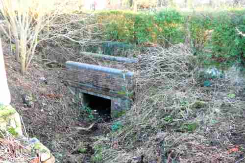
On the Izaak Walton side of the railway line in Cresswell – and on either side of the road – are two culverts. Most of the time, you could barely see them because they had become completely overgrown and choked with weeds. You wouldn’t have thought water flowed through them at all.
But, they seem now to have been cleared – at least enough to get the water flowing again.

The culvert on the east side of the road, with the Blythe Park boundary hedge behind it. If you think it looks overgrown now, you should have seen it before!
Who has been doing it is not clear. This is probably private railway land (on the eastern side at least), though it does abut up against the Blythe Park boundary – but Severn-Trent also has a responsibility for all water-courses in the county.
The stream runs under the road.

You can see the west-side culvert more easily, especially now the vegetation is cut back: just walk a couple of yards up the unmade land opposite the Izaak. Above it in this photograph are the lights of the railway crossing
Or is it someone else?
Three rivers
Looking at the puddles and pools in it nowadays, most people do not realise that this stream was once strong enough to power a small water-mill, which was along its course in the old days. The mill site was somewhere along the unmade lane opposite the Izaak that runs up to the present Cresswell pumping station.
In fact, some older people say that the ruined brickwork which you can just see in the undergrowth about a hundred yards up the lane is the remains of the old mill.
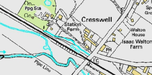
As you can see from the map below, the water-course was not just a muddy ditch, as it is now, but a proper stream.

The thick blue lines on this map are streams or rivers, with the thickest one being the River Blithe. The thick dark line is the railway line. ‘PH’ means ‘public house, and is the Izaak. Thanks to Staffordshire Local View for the use of the map
However, sometime in the middle of the last century (perhaps?), the three streams were diverted into the one river that you see now passing under Cresswell Bridge. In those days, the rivers regularly flooded, so the problem had to be sorted.
But this account raises more questions than answers.
Do YOU know more about the old mill-stream? Please let us know… Just email us, or use the comments box below

I see that there was a mill at Cresswell, near the railway station, which on the 1880 OS map is shown as a “bone mill”, which appears to have been demolished sometime before the 1920’s.
I see also there is shown, on the same map, further downstream, a small colour-mill on a mill stream, which seems to suggest it was water powered, and this was, I believe, what was eventually to become the Blythe Colour Works. Am I correct in believing that? (If so that would considerably extend the 100 years quoted for colour pigment production on the site).
is there more information on either of these two mills?
JH
LikeLike
You might be surprised exactly how old the mill site actually is – being on the Yates map of the late 18th century (1776)….but it may be even older still !
How old? Well … all will be revealed in the Draycott History Walk event, which is scheduled for July
Lev Wood
LikeLike
John Doxey of Blythe Bridge was a colour manufacturer who took over the old mill in Waterworks Lane Cresswell. Originally the idea was to drill for coal in Draycott Parish but this was not possible.
In 1846 a borehole was drilled at Cresswell nearly two miles south of the southern edge of the exposed coal seam and carried down 600 feet into Red Marl Keuper sandstone,then abandoned. This drilling was certainly in Waterworks Lane Cresswell.
John Doxey and the years tie in with all this; and the footings of John Doxeys mill can still be seen in Waterworks Lane.
Doxey was in Cresswell in 1842 to 1846 approx.
Some years later in 1875 Charles Coyney Esq leased property mill and lands situated at Cookshill (in the parish of Caverswall) for 21 years to John Doxey of blythe Bridge. Lease included Dwelling House, later a corn mill , mill race, mill dam, mill pool, mill ponds, pools and machinery working gear. This seems to say that Doxey now saw himself as a miller.
Bazo
LikeLike
The mill you refer to is situated in the old unmade road that leads to the present day Severn Trent Pumping station. It is 200 –300 metres on the left hand side amid lots of undergrowth. This mill pre dates all others, even those that were on the Blythe Colours site.
This mill was a flint-grinding mill powered by the Blithe river. It was operated by a John Doxey who was there for only a couple of years. He started the operation around 1842 and also had a facility at Cookshill, Caverswall. The operation closed around 1844. Four years later the Railway opened.
This detail was found in Kelly’s & Whites Business Directories for Draycott en le Moors. It can be found in Blythe Bridge library
Bazo
LikeLike